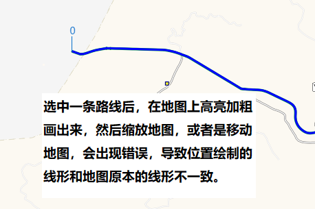
选中一条路线后,在地图上画出来,然后缩放地图,或者是移动地图,会出现错误,导致位置绘制的线形和地图原本的线形不一致。
错误信息:
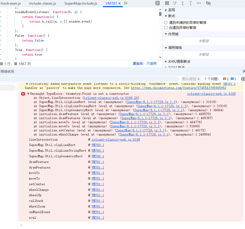
iclient-classic-es6.js:6188 Uncaught TypeError: Geometry.Point is not a constructor
at Object.lineIntersection (iclient-classic-es6.js:6188:26)
at SuperMap.Util.clipLineRect (eval at <anonymous> (SuperMap-8.1.1-17729.js:1:1), <anonymous>:1:30970)
at SuperMap.Util.clipLineStringRect (eval at <anonymous> (SuperMap-8.1.1-17729.js:1:1), <anonymous>:1:31519)
at SuperMap.Util.clipGeometryRect (eval at <anonymous> (SuperMap-8.1.1-17729.js:1:1), <anonymous>:1:36064)
at initialize.drawFeature (eval at <anonymous> (SuperMap-8.1.1-17729.js:3:1), <anonymous>:1:468570)
at initialize.drawFeatures (eval at <anonymous> (SuperMap-8.1.1-17729.js:3:1), <anonymous>:1:465387)
at initialize.moveTo (eval at <anonymous> (SuperMap-8.1.1-17729.js:3:1), <anonymous>:1:464776)
at initialize.moveTo (eval at <anonymous> (SuperMap-8.1.1-17729.js:3:1), <anonymous>:1:53690)
at initialize.setCenter (eval at <anonymous> (SuperMap-8.1.1-17729.js:3:1), <anonymous>:1:49172)
at initialize.wheelChange (eval at <anonymous> (SuperMap-8.1.1-17729.js:3:1), <anonymous>:1:249864)
lineIntersection @ iclient-classic-es6.js:6188
SuperMap.Util.clipLineRect @ VM780:1
SuperMap.Util.clipLineStringRect @ VM780:1
SuperMap.Util.clipGeometryRect @ VM780:1
drawFeature @ VM781:1
drawFeatures @ VM781:1
moveTo @ VM781:1
moveTo @ VM781:1
setCenter @ VM781:1
wheelChange @ VM781:1
wheelDown @ VM781:1
callback @ VM781:1
wheelZoom @ VM781:1
onWheelEvent @ VM781:1
eval @ VM781:1
主要代码:
vectorLayer = new SuperMap.Layer.Vector("VectorLayer")
从服务器查询后,将线形放入图层
feature = result.recordsets[i].features[j];
feature.style = controlStyle;
workLayer.addFeatures(feature);
前端版本:supermap-iclient-javascript-classic-2025.zip
iserver版本: iServer 11i(2024) (11.3.0-win64)


